Snow Shoeing Along Meeks Creek

The sun was out, and the snow was deep. It was a perfect day for snow shoeing. We parked along side Highway 89 (south of Tahoe City), strapped on shoes rented from Tahoe Dave’s, and stepped off the road onto the snowy bank near the Meeks Bay Resort.

We followed the gated dirt road now packed with snow about 1.4 miles, admiring and hugging the trees along the way, stopping as the road ended and the trail began to climb.

IMG_4793.jpg

We ate our snacks on logs then headed slowly back to the car, this time across frozen Meeks Creek, choosing to make our own trail through the snowy meadow.

IMG_4806.jpg

Trip taken December 2015.

dipsea News, Breaking dipsea News and More: Marin Independent Journal

ca-195dipsea News, Breaking dipsea News and More: Marin Independent Journal.

I’ve been lucky enough to be a spectator at two of the oldest running races in U.S.: the Boston Marathon (2nd oldest road race) and the Dipsea Race (oldest trail race). You’ve heard of the Boston Marathon but have you heard of the Dipsea?

The Dipsea Race was started in 1905 when a group of runners decided to run the trail from Mill Valley, California, over Mount Tamalpais, to Stinson Beach. That year, 100 people ran it. Now only 1500 people are lucky enough to run the steep and treacherous 7.4-mile race every year.

As a child, we would wave good-bye to my dad at the start of the race then drive 10 plus miles along the windy roads, through the fog, hoping to reach the finish before he did. It was a tough balance – driving fast enough but not too fast or we would get car sick. Then we’d park and run to watch him finish.

We’d watch Dad and the other runners straggle in, bloody and muddy, many getting sick just before or after they finished. I heard stories of those never ending steps (676 steps and as high as a 50 story building), runners coming up fast from behind, slipping on the mud, and taking short cuts. There was no doubt that the race was a grueling one.

My dad no longer runs the race, but my brother does and so does my sister-in-law. They’ve run the single Dipsea, the Double Dipsea, and even the Quadruple Dipsea. An old friend of my dad’s will run it this year for the 45th year in a row. Due to various running injuries, I’d given up the idea of ever running it myself. But a few years ago, on a crisp December day, I ran the course. Not from Mill Valley to Stinson Beach but from Stinson Beach to Mill Valley. I didn’t run the race, but I did run the course. I ran down the steps instead of up them.

For more information on the race, read the website above or check out this article. http://www.runnersworld.com/trail-running-training/tough-love?page=single

Hiking in Marin

One of my favorite things about Marin County, just north of San Francisco, is its accessibility to hiking. Within an hour or less from urban life, you can be hiking on challenging trails with a view of the ocean or in the shade of redwood trees.

On my last visit to Marin, a friend and I went for a hike in the Tennessee Valley area of the Marin Headlands.

Trail head

It was a blustery but sunny day. We hiked along the Tennessee Valley Road to the confluence of the Old Springs Trail and took a left, eventually turning on the Wolf Ridge Trail toward Hill 88.

MH Trail

What was once a former Nike Missile Radar Station, Hill 88 is now graffiti covered buildings with incredible views of the city.

SF View

After exploring Hill 88, we hiked back along the Wolf Ridge trail, wondering about the cannon we could see far below (but without the time or the inclination to discover it for ourselves).

Instead we headed back down the Coastal Trail, toward Tennessee Valley Road and our car. Soon we were back in civilization, eating tacos for lunch (see Tacos in Sausalito), and going about our day.

For a map of the trails in the Marin Headlands click here.

Trip taken: January 2014.

When to Visit Walden Pond

I first discovered Walden Pond when a friend took me there for a summer evening swim. I’d studied the Transcendentalists in college, had heard of Thoreau but had never read Walden. We walked along the trail to a place my friend knew, away from the crowds. We swam to cool off from the hot summer air.

Since then I’ve visited Walden several times. In the morning, when people gather to swim; during the day, when the beaches are crowded with small children; and on the weekends, when people from the city seek an escape from the summer heat. I’ve picnicked along its banks, hiked along its trails, swam and kayaked its cool waters. But until last November, my visits have remained in the summer months. Last November, I discovered how magical Walden Pond can be without the heat and without the crowds.

On the Pond Banks Cabin SiteWalden Pond

Trip taken November 2013.

Cool Off in Jewel Cave

If you’re hot and in the Black Hills of South Dakota, there’s an easy way to cool down: enter one of the area’s caves. The national monuments of Wind Cave and Jewel Cave are both located in the southwest corner of South Dakota, not too far from Mount Rushmore. We visited Wind Cave on a previous South Dakota trip in 2005. This trip we focused on Jewel Cave, the third longest cave in the world.

While there is a visitor center which you can visit at no cost, to really see the cave’s jewels, you need to take a tour. Jewel Cave National Monument offers four tours which range in time, price, and strenuous ability: the scenic tour, discovery tour, historic lantern tour, and wild caving tour.

Jewel Cave jewels

Although my spelunking experienced husband would have preferred the 4-hour wild caving tour, we chose the scenic tour, a moderately strenuous 1.5-hour tour.

Jewel Cave Sights

After descending deep underground (in an elevator), we (and about 25 others) followed our tour guide on a paved trail through chambers decorated with calcite crystals and other speleothems.

Scenic Tour

Although we traveled only 1/2 mile, there are over 170 miles of mapped and surveyed passages. If you want to do more, the wild caving tour takes you along a 2/3 mile route, but you will have to belly crawl through a passage 8 1/2 inches high by 24 inches wide.

Jewel Cave Visitors

Tickets are only available on a first come first served basis and, except for the wild caving tour, must be purchased the day of the tour. My advice – get there early to choose the time of your tour. The entrance to Jewel Cave is located 13 miles west of the city of Custer, South Dakota.

Jewel Cave National Monument

Trip taken July 2013.

When the Badlands Aren’t So Bad

Thunder in BadlandsIf you were driving a stagecoach or on horseback and came across this expanse of arid rock, you might call it a “miserable gully,” but if you’re interested in geological features and you have plenty of water, this 244,000-acre national park in South Dakota is worth exploring.

Hiking

I’ve been to Badlands National Park several times in my life, but the most interesting and rewarding experiences have been the times I’ve stayed in the park. Last summer, we stayed in brand new cabins with AC.

Cabin IMG_1963

When the sun’s rays are not quite as intense, the light colored formations are not as blinding. I no longer have to squint.

And when the sun sets (as late as 8:30 p.m. in the summer), the spires take on their own personality. There is an evening program every night at 9 p.m. followed by night sky viewing through large telescopes. Every morning, just before it gets really hot, there is a ranger-led walk at 8:30.

Ranger

Be sure to check out the Ben Reifel Visitor Center where, besides learning about the rock formations and nearby floral and fauna, you can see real paleontologists working on fossils.

Badlands Visitor Center

The gift store at the Cedar Pass Lodge is one of the best in the area for finding unique and quality South Dakota items, everything from books to jewelry to herbal tea.

If you’re hungry, check out the Cedar Pass Restaurant. In addition to the Sioux Indian Fry Bread and Taco, the restaurant includes South Dakota steak and fish and many gluten-free items.

Trip taken July 2013.

10 Reasons to Visit South Dakota

Growing up in California, my friends could never understand why I wanted to go to South Dakota. As far as they were concerned, it was in the middle of the country where there was nothing to do. But I knew they were wrong. Besides the fact that my grandparents lived there, I loved it. South Dakota offered things my hometown and home state didn’t: prairies of undulating grasses, buffalo, real cowboys, Native Americans, and lots of space.

IMG_1692 IMG_0130_MG_1922

Cowboys

In South Dakota, I could ride horseback on my uncle’s horses, pick choke cherries along the Missouri River, go swimming in the Oahe Dam, eat buffalo burgers, go to a rodeo, and visit a palace made of corn.

So, here’s a list of 10 places to go and things to do in South Dakota, listed from east to west across the state. Written by someone who’s got roots in South Dakota. Stay tuned for more details in future blog posts.

  • The Corn Palace: Over 275,000 ears of corn are used each year to create a mural on the exterior of the Corn Palace located in Mitchell. The palace is open year round and is free to visit.
  • Pierre and Fort Pierre: With its two lakes, the Missouri River, and over 2,200 miles of shoreline, the area offers plenty of swimming, boating, fishing. Learn about South Dakota’s history at the South Dakota Heritage Museum or the Casey Tibbs Museum and be sure to visit the Fort Pierre Rodeo on the 4th of July.Pierre
  • Wall Drug Store: Originally just a drug store, this rambling place now sells everything from laminated placemats to cowboy boots. If you’re hungry, you can get a buffalo burger or ice cream along with a free glass of water and a 5 cent cup of coffee.
  • Badlands National Park: Visit this expanse of mixed grass prairie and geologic deposits, where ancient animals once roamed. Here you can see buffalo and prairie dogs. You might even see archaelogists at work in one of the world’s richest fossil beds.
  • Mount Rushmore National Memorial: One of the more famous sculptures in the world, Mount Rushmore includes the faces of four American presidents in its granite face.IMG_0110
  • Crazy Horse Memorial: In addition, to the actual sculpture of Crazy Horse, the memorial includes museums and collections of Native American art and artifacts.
  • Deadwood: In this national historic landmark, you can see a reenactment of the shooting of Wild Bill Hickok, visit the grave of Calamity Jane, gamble in its gaming halls, and visit Tatanka, Kevin Costner’s tribute to the buffalo.
  • Wind Cave National Park and Jewel Cave National Monument: If you like spelunking, South Dakota has two easily accessible caves worth a visit. Both offer a variety of ranger led tours, some more adventurous and more strenuous than others.Jewel Cave
  • Custer State Park: Located in the Black Hills near Mount Rushmore, Custer State Park has 1,300 buffalo on its 71,000 acres. You can camp or stay at a lodge, swim in Sylvan Lake, drive the twisty Needles Highway, or hike the state’s highest peak (Harney Peak).
  • The Mammoth Site of Hot Springs, SD: The Mammoth Site is an active paleontological dig site and includes the largest concentration of mammoth remains in the world. On your visit, you can see real paleontologists at work, dig for fossil replicas, learn proper excavation techniques, or learn an ancient paleo Native American hunting technique.

Enjoy your trip to South Dakota!

Multiple trips taken, most recently in 2013.

Weekly Photo Challenge: Threes

WordPress has a weekly photo challenge, and this week, the challenge is to tell a story with three photos. 

What do you do when you’re out in the middle of nowhere, backpacking, and you discover a rubber ball?

Finding the Ball

Do you leave it in the woods? Pack it in your pack?

Carrying the Ball

Or carry it with you, bouncing it and tossing it along the trail?

Tossing the Ball

To see some other three photo stories, click here.

Stop and Focus

It’s hard to take time for yourself during the holidays. But this last week, I made it a point to get outside. With several inches of snow and a stir crazy dog, I strapped on my snow shoes two days and my cross country skis another two days. I didn’t go out for long – as little as 30 minutes one day and as long as an hour another, but the fresh air and exercise helped me slow down and take a break from my never ending list.

Tracks

During these last few days before Christmas and the end of 2013, remember to stop and take a break and find a focus in the holiday blur.

Dog in Snow

IMG_1686

Trip taken December 2013.

Wildflowers on the Dias Ridge Trail

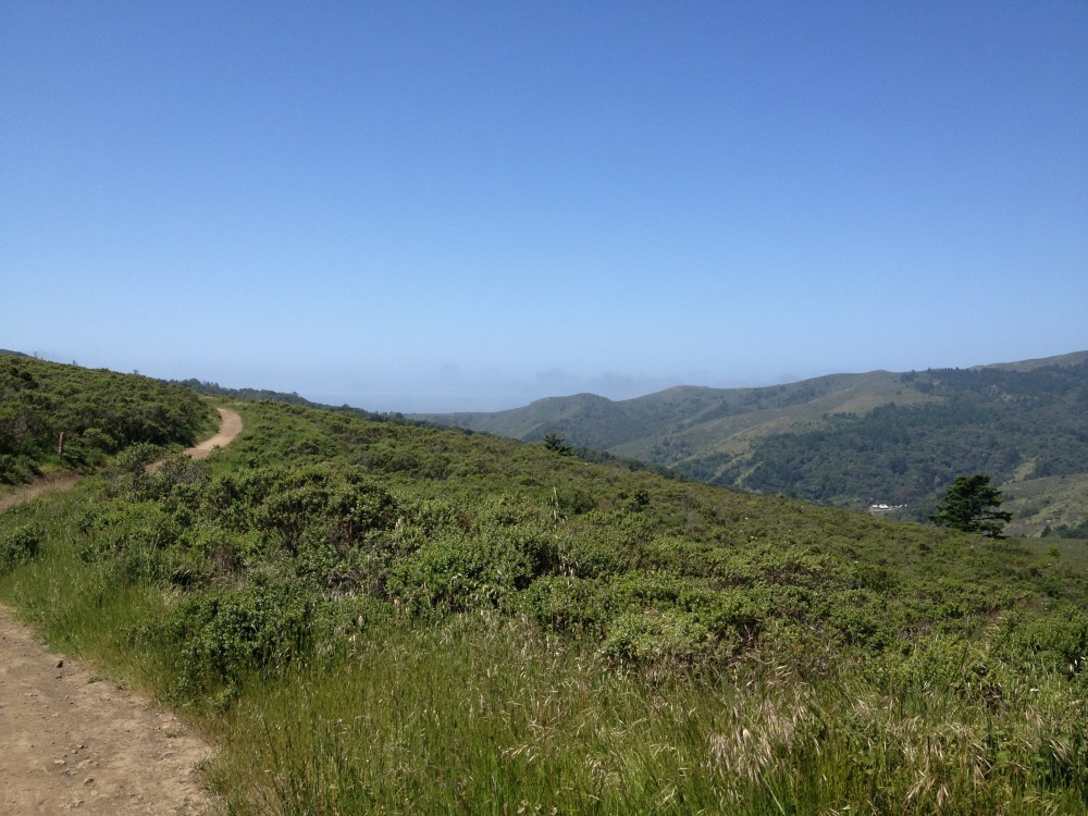
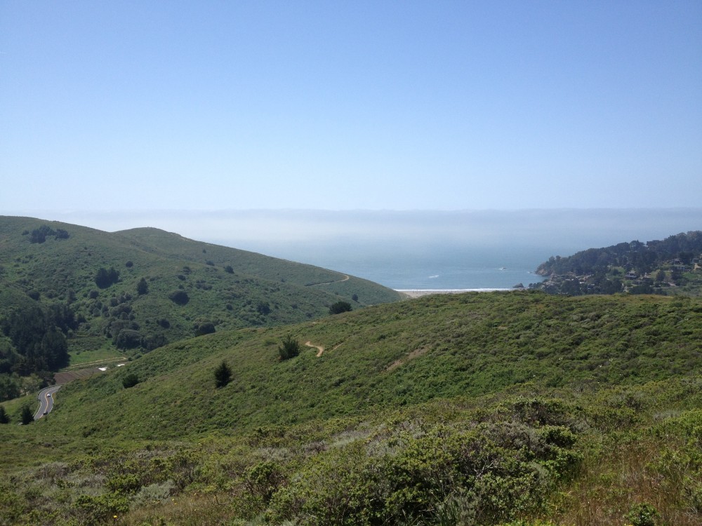
Looking for a gentle hike with spectacular views and a rewarding destination? The Dias Ridge Trail in Mount Tamalpais State Park, a few miles north of San Francisco, meanders just 3 miles from Panoramic Highway down to the Pelican Inn and Muir Beach.

As I hiked the trail last weekend, I discovered a few of the 20,000 or more coastal and grassland plants transplanted by volunteers before the trail opened in 2010.

Trail on hillside

Yellow and orange California poppies, pink wild geraniums, purple lupine, white iris, red Indian paintbrush, and even white wild strawberry blossoms brightened the trail.

I made way for the mountain bikers, runners, and faster hikers and dodged the abundant poison oak growing thickly among its look alike, the blackberry plant.

Shiny green leaves pf three

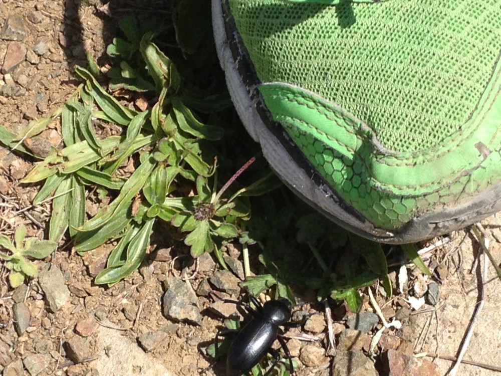
I stepped carefully to avoid a black beetle and watched him scurry across the dirt trail.

Black beetle near green sneaker

I listened to the sounds of rattlesnake grass when shaken by the wind and discovered that the blooming cow parsnip really does smell like warm corn tortillas.

After stunning sights of the Pacific Ocean and the ridge of Mount Tam on this warm April day, we stopped for lunch (fish and chips and a ploughman’s lunch) at the Pelican Inn.

View of Pacific Ocean in distance beyond green hills

White inn in distance at end of trail

Return to your car for a 6-mile (and more rigorous) round trip hike or send someone back up the trail to get the car, as we did. Muir Beach is only a short hike from the Pelican Inn.

If you go, follow Shoreline Highway from the Mill Valley/Stinson Beach exit off Highway 101. Turn right onto Panoramic Highway and park in one of the dirt pullouts just ahead. Follow the trailhead signs to reach Dias Ridge Trail.

Trip taken April 2013